A mixed community
A range of homes, including a target of 35% affordable housing and homes responding to different stages of life.
Land at Dovers Farm · Reigate
We are consulting on emerging proposals for approximately 120 new homes, new green spaces and better walking and cycling connections.
The opportunity
Dovers Farm is allocated under Policy SSW9 in Reigate & Banstead Borough Council’s Development Management Plan. Under this, Dovers Farm is allocated for approximately 120 homes and one traveller pitch.
The emerging design responds to the site’s mature boundaries, nearby homes, public rights of way and the countryside edge. It is an early proposal and community feedback will help inform the next stage.
A range of homes, including a target of 35% affordable housing and homes responding to different stages of life.
A central green, retained trees, enhanced woodland and new planting woven through the neighbourhood.
New pedestrian and cycle links connecting with local routes, Earlswood Common and the wider area.
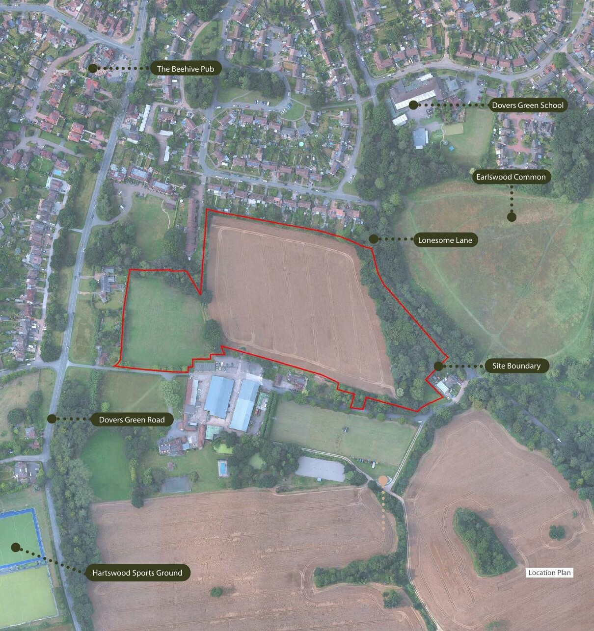
The site
The proposals lie at the southern edge of Woodhatch next to Ashdown Road, close to Dovers Green School and Woodhatch Local Centre.
The land currently comprises open agricultural fields with a belt of woodland to the east, bounded by Lonesome Lane, with the A217 to the west and the Courtyard Business Centre to the south.
View the site on Google MapsLocal connections
Select a local destination to view its relationship with Dovers Farm. The map can be moved, zoomed and opened for directions.
Planning context
The adopted Reigate & Banstead Development Management Plan allocates Dovers Farm for residential development. Policy SSW9, on pages 127–128, establishes the allocation and the requirements any scheme must address.
Read the adopted Development Management PlanApproximately 120 homes, of which 42 will be affordable homes, including up to 48 homes adaptable for changing needs.
Enhance biodiversity and green infrastructure, connect with the wider countryside and provide an appropriate transition at the southern countryside edge.
Keep development out of Flood Zones 2 and 3, provide comprehensive sustainable drainage, improve and buffer the main river and ditch network, and undertake a site-specific flood risk assessment.
Protect the setting of adjoining listed buildings, retain existing trees and hedgerows - particularly the woodland along Lonesome Lane - and reinforce the southern Green Belt boundary with planting.
Provide safe access, improve walking and cycling facilities on Dovers Green Road and Lonesome Lane, upgrade bridleway BW61, assess junction impacts and address rat-running on nearby roads.
Provide suitable on-site public open space and play facilities, together with approximately one serviced traveller pitch integrated with the residential development unless an acceptable controlled alternative is demonstrated.
Homes and infrastructure
The proposals aim to provide much-needed homes while ensuring that it contributes to alleviate pressure on local services such as GP practices, Schools, Roads and Local Facilities.
Community Infrastructure Levy
The Council has adopted a developer obligations levy known as Community Infrastructure Levy (CIL). This is a proportionate payment, based on floor area that is paid to the Council by the Developer to help the Council fund the infrastructure, facilities and services needed to support new homes and businesses. This levy is controlled and spent by the council.
Whilst proposals are emerging still it is anticipated that this will deliver over £2.5m to the council for improvements to local services.
Find out more about the Community Infrastructure LevyAround 42 of the proposed homes would be affordable, this is 35% of the whole development. The final mix of affordable homes has not been agreed but will be discussed with the Council to help meet local housing needs.
The emerging proposals
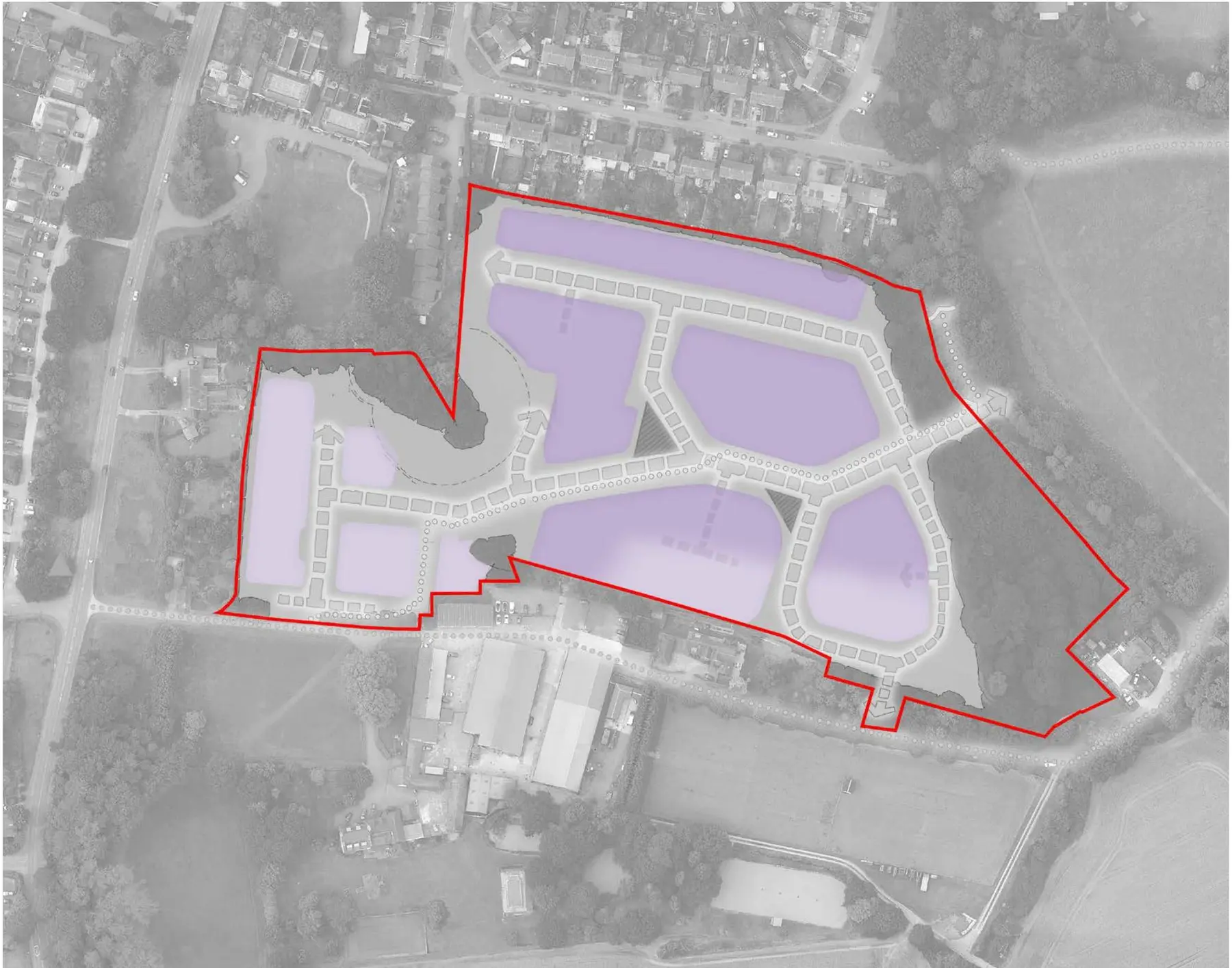
The design develops through five connected stages. These plans are illustrative and will evolve through technical work, discussions with the council and community feedback.
The emerging framework is shaped by technical work covering landscape, ecology, trees, drainage, heritage, access and neighbouring amenity.
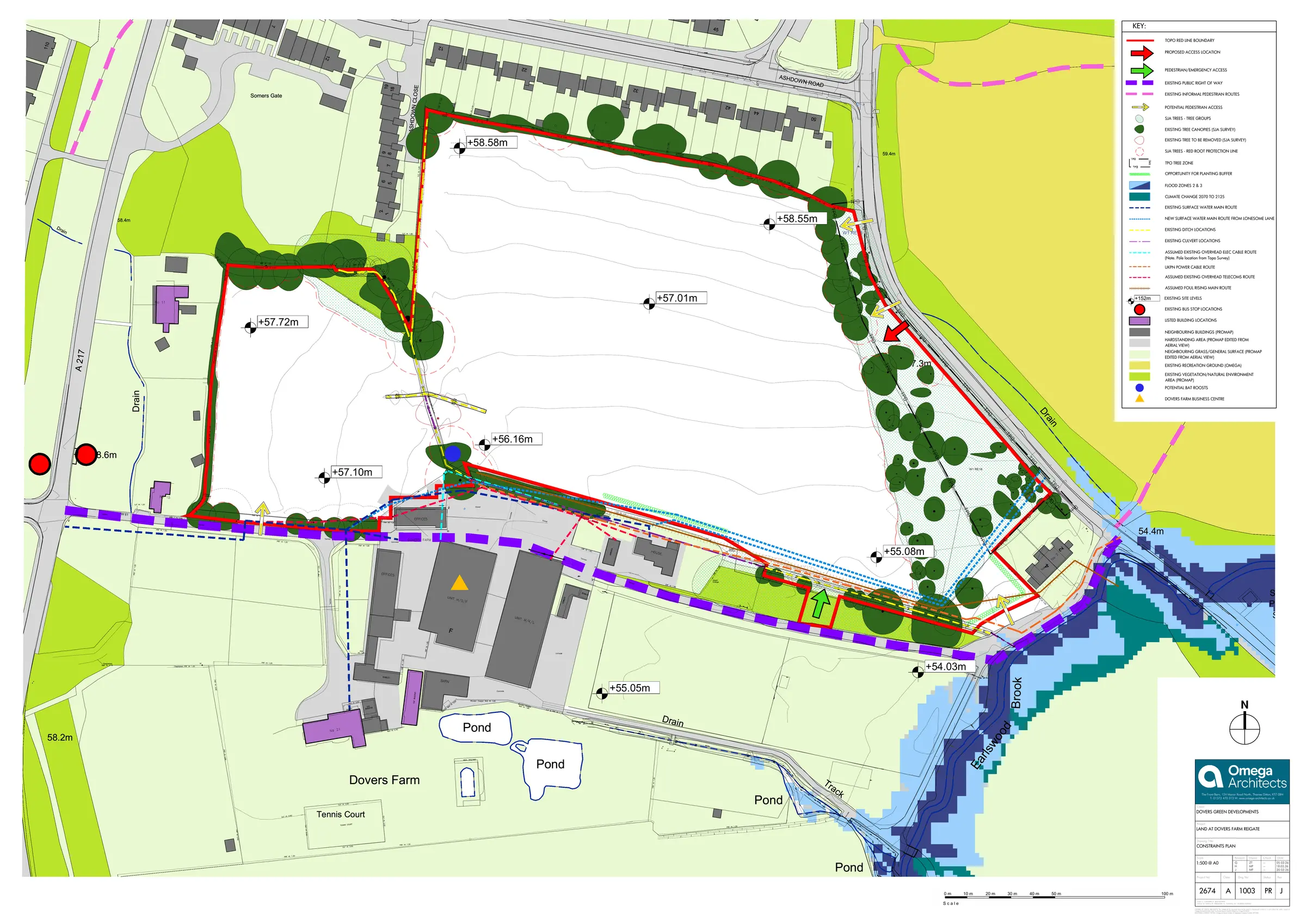
The concept starts with the site’s landscape and connections. The emerging development should:
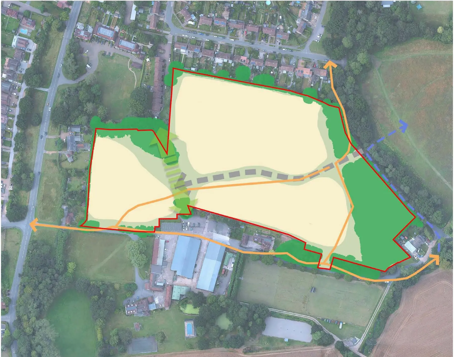
The framework translates those principles into green space, development parcels, routes and edges. It places a central open space around existing trees, supports east–west movement and responds carefully to neighbouring homes and the countryside.
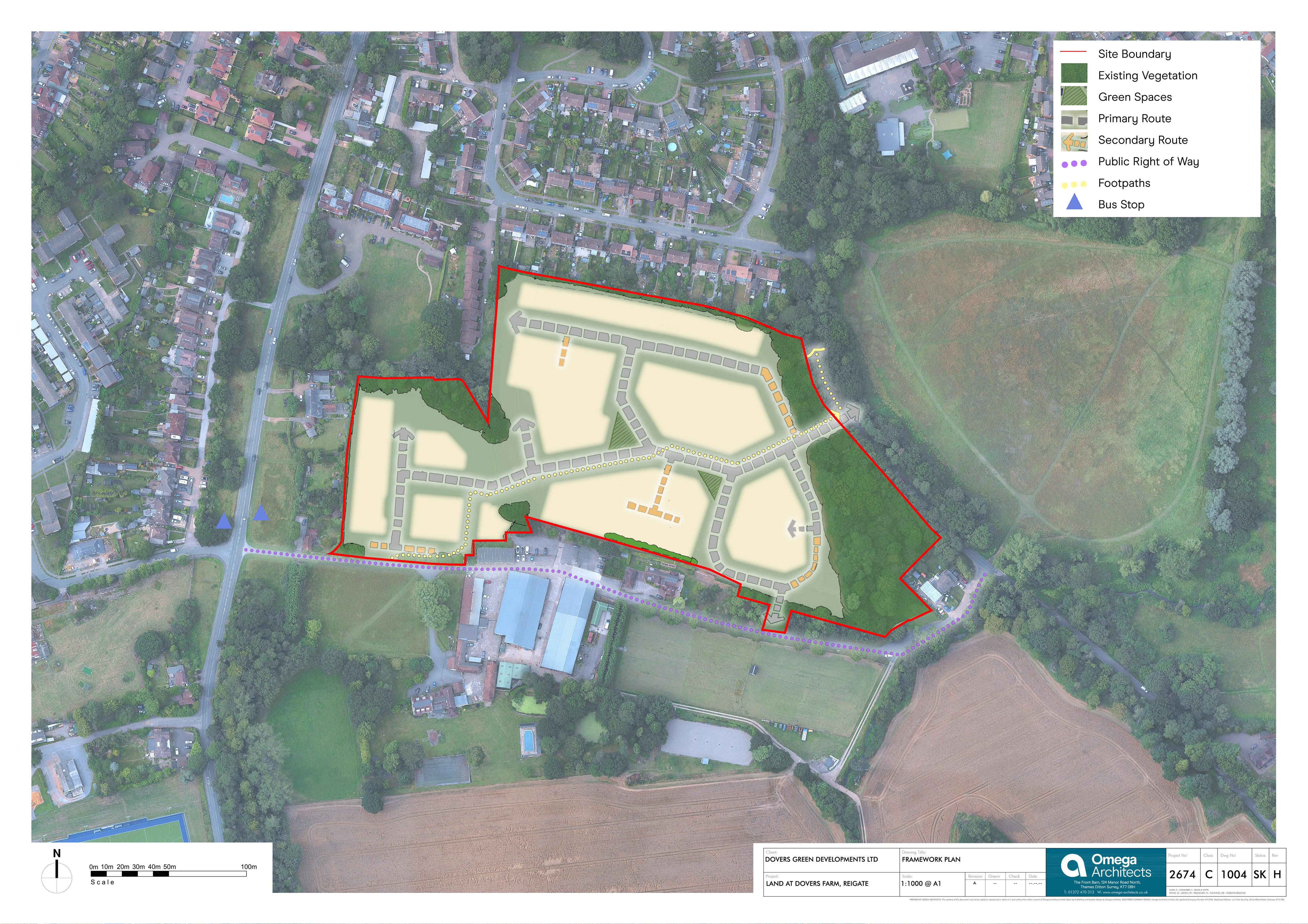
The framework identifies just over three hectares of development area, capable of accommodating up to 120 homes at an average density of approximately 35–40 dwellings per hectare.
The emerging proposals seek to respond to the landscape, townscape and heritage by:
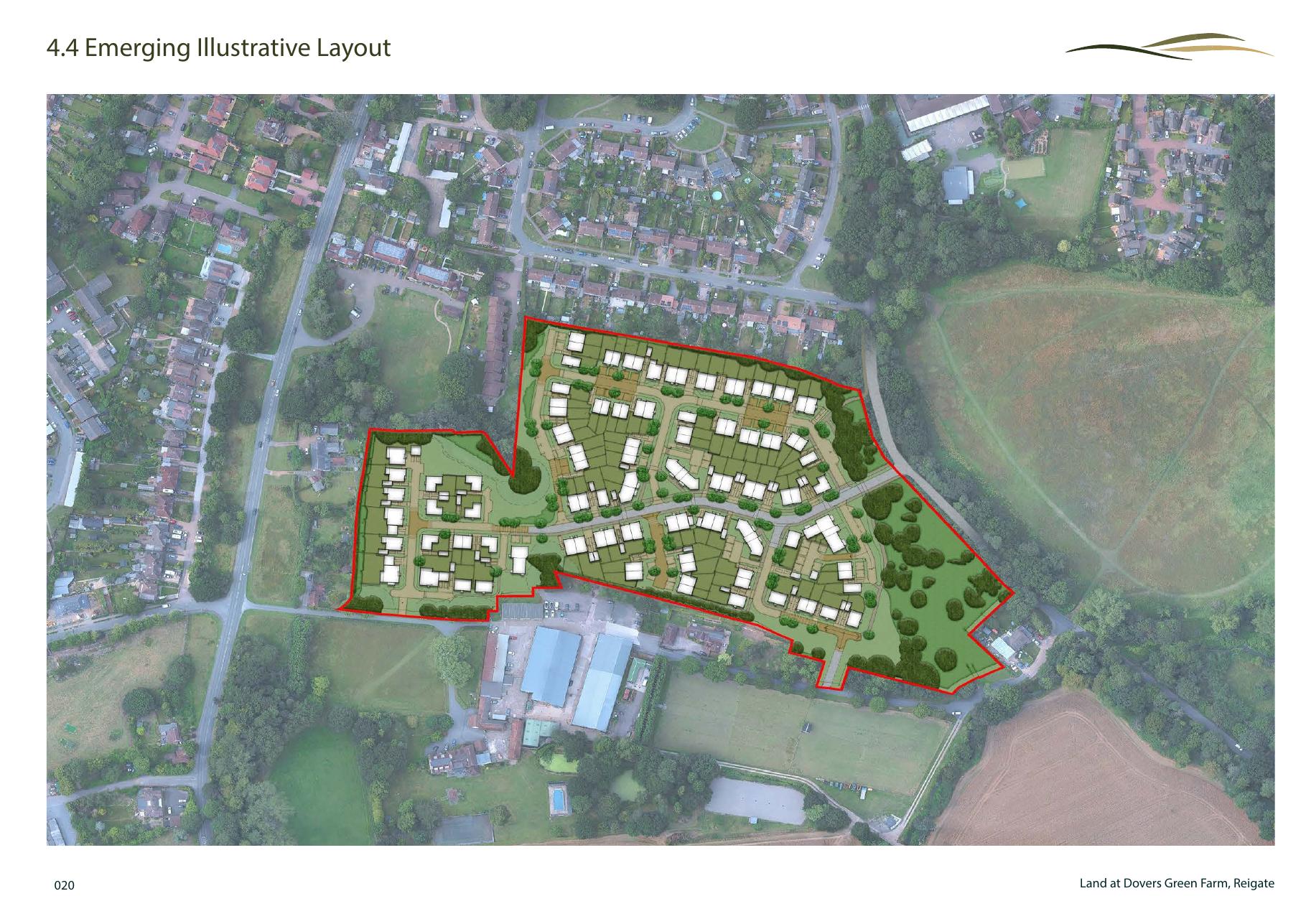
The illustrative layout shows how varied homes, streets, green space and retained landscape could come together within the development framework.
Explore the plans
Select a plan, then zoom in to inspect the detail or overlay another stage for a direct comparison. The five stages are explained in full above.
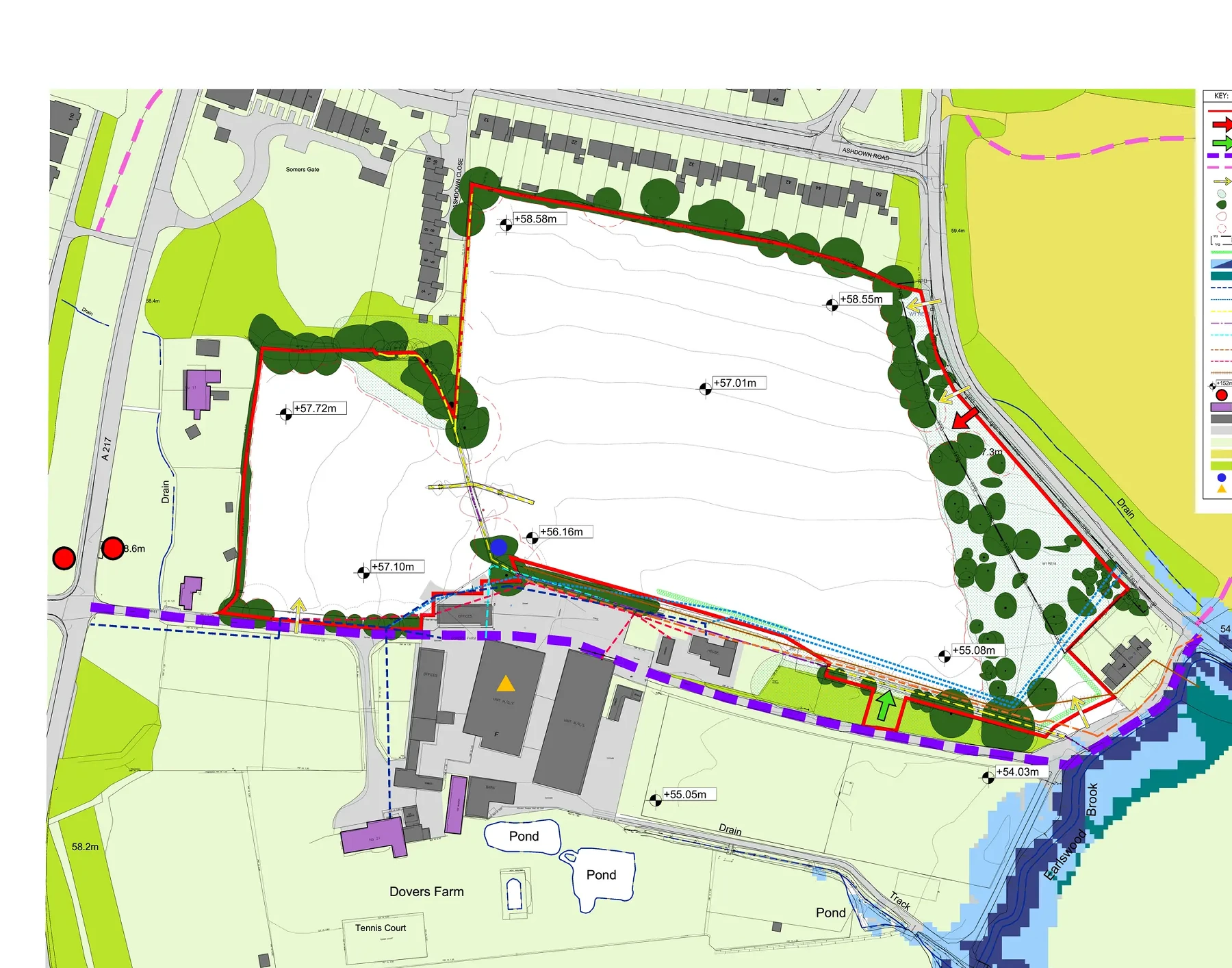
Use the controls to zoom. When zoomed, drag the plan or use the arrow keys to move both layers together.
Frequently asked questions
No. The allocated Dovers Farm site is outside the Green Belt. It was removed as part of Reigate & Banstead Borough Council’s Development Management Plan, adopted in September 2019, alongside its allocation for housing under Policy SSW9.
The countryside beyond the southern boundary remains in the Green Belt. The proposals must respect this setting, and Policy SSW9 requires planting to strengthen the boundary. The allocation does not grant planning permission: the detailed proposals still need to be assessed through a planning application.
The proposals are anticipated to contribute over £2.5 million through the Community Infrastructure Levy (CIL), CIL is a development tax which the Council will collect and spend on improvements to Roads, Schools, GP Practices, Hospitals and wider infrastructure.
The emerging proposals seek protect species and habitats by retaining and enhancing woodland, trees and hedgerows with additional native planting and connected habitats.
Overall the proposals have to enhance the current biodiversity base value by 10% to ensure what is incorporated into the development proposals is better than what is there now.
Ecological surveys have been undertaken, which confirm there are no protected species on site. Nevertheless the proposals will be designed to ensure all necessary protections measures are included.
All new developments have to assess their impacts through a 'Transport Assessment'. This will consider the existing congestion and road safety problems alongside additional journeys from Dovers Farm and other relevant developments to ascertain if conditions are unacceptably worse. Specific measures have not yet been agreed, but this will be assessed alongside the funded improvements to ascertain if further contributions or works will be required.
Yes. Policy SSW9 of the adopted Development Management Plan allocates the 6.1 hectare site for approximately 120 homes, including approximately 25 units of housing for older people and approximately one traveller pitch.
No. These are emerging proposals prepared for pre-application discussion. Feedback and further technical work will inform the design before any planning application is submitted.
The framework places private gardens towards parts of the northern boundary, uses lower-density development to the west and retains mature boundary vegetation to help protect privacy and amenity.
The allocation requires development to avoid Flood Zones 2 and 3 and a site-specific flood risk assessment. The landscape strategy also identifies opportunities for surface-water attenuation and improvements to the ditch network.
The project team will review the feedback alongside technical evidence and discussions with the council. The proposals may then be refined before a planning application is prepared.
Have your say
Please review the emerging proposals and tell us what you support, what concerns you, and what could be improved.